AL HAMRA (the Red Town): The traditional mud-brick town of Al Hamra (left) stands at the southern foot of the Oman's highest peak, the 10,000 ft Jebel Shams. Amid this breathtaking scenery the ancient town seems to spring from the very bedrock.
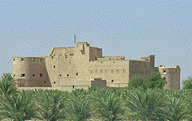
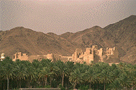
Rustaq: We will also see some of the northern rim of the Jebel Akhdar in particular visiting the town and fort of Rustaq. Rustaq Fort was first established in pre-Islamic times and for a while, during the 18th century, served as the capital of Oman. Today the fort holds tombs of some of Oman's early rules,
including the founder of the present Albusaidi dynasty.
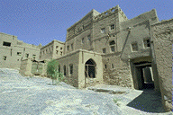
MISFAH is without doubt one of the most
picturesque villages in Oman. Resting high on the side of a deep wadi on
the southern slope of the Jebel Akhdar, Misfat is built entirely of stone
and mud-brick Immediately below the village a system of terraced fields,
fed by a tumbling central falaj (aqueduct), plunges straight down the side
of the wadi in spectacular fashion . Aproached along a single dirt track,
even today cars are not permitted in the village which continues to maintain
its traditional agricultural way of life.
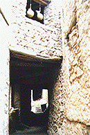
JABRIN: Ten miles west of Bahla, following the foot of the jebel, and a short distance out onto the desert lies the historic oasis and 17th century fortress of Jabrin. The fort's maze of rooms were once an Islamic college and today boast many unique design features and finely painted ceilings.
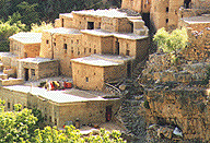
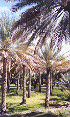
High above Birkat, 6000 feet up on the Jebel Akhdar plateau, lie the terraced villages of Bani Habib and Sharijah. Here, above the heat of the desert and in ancient terraced fields, Omani farmers grow vines, limes, pomegranates, onions and other vegetables for market in nearby Nizwa and the capital area.
BAHLA: The historic fort and walled town of Bahla lie in the shadow of the jebel, 20 miles west of Nizwa. Dating back to the 3rd millennium BCE the entire complex of fort and town are recognized as a World Heritage Site The town stands amid acres of date palms which are in turn surrounded by 7 miles of ancient defensive wall
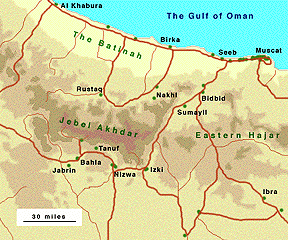
Rising to nearly 10,000 feet, the Jebel Akhdar
(or Green Mountains) form the central section of
the Hajar Range that stretches over 400 miles from the Musandam peninsula
in the west to the coastal town of Sur in the east. Jebel Akhdar's towering
peaks, plunging valleys, date palm groves hidden terraced villages
offer a stark contrast to the flat of the fertile Batinah coast to the
north and the great plateau of southern rabia to the south. This untainous
region is divided into two distinct zones, the northern slope sheltering
the towns of Rustaq and Nakhl, and the southern slope of the interior We
begin to the south at the oasis town of Nizwa.
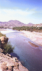
NIZWA was once the capital of Oman. Today it is best known for its large fort and silver souq. Dominated by a huge circular tower, the fort stands in the center of town, surrounded by a mix of local markets and ancient mud-brick homes. The Silver Souq is the best in Oman, an excellent place to buy a tradition Omani Khunjar (ceremonial dagger), made locally by Omani craftsmen. Nizwa has also long been an important agricultural center thanks to farms fed by Oman's largest falaj (aqueduct) called the Falaj Daris, built in 1680 by the Imam, Sultan Saif . The road to Nizwa from Muscat takes us through the Sumail Gap. Here the Wadi Sumail cuts a deep cleft through the Hajar range permitting access to the interior from the Batinah coast and the Capital Area. Winter storms often fill this usually dry riverbed sometimes making transit difficult. Even today the modern highway from Muscat to Nizwa and Salalah is occasionally cut by rising water. The photograph (left) shows the wadi in flood close to the village of Fanja. As we emerge at the southern end of the Sumail Gap we pass the wayside oasis of Birkat Al Mawrs.Here ancient date groves are fed year-round by a falaj (aqueduct) emanating from the foot of the nearby Jebel Saiq. In addition to her picturesque date groves Birkat also possesses a fine fort.